Flood Event Review – New York City, September 2023
- Written by
 Dr Vivian Camacho
Written by Previsico’s Back End Developer Vivian Camacho-Suarez, PhD
Overview
On September 29, 2023, heavy rainfall caused major flooding in parts of the metropolitan New York area. New York was declared a state of emergency for five boroughs, and all counties (Hicks, 2023).
The flooding disrupted train services in Brooklyn and the entire New York City Subway system. Metro-North Railroad had to suspend three lines, and several boroughs experienced flooding on multiple streets. LaGuardia Airport and John F. Kenney Airport were affected, with almost 60 flights cancelled.
Rainfall Information
Rainfall records indicate that at JFK Airport, an unprecedented downpour of nearly 203 mm within a single day occurred, the highest rainfall records dating back to 1948. Similarly, the Brooklyn area was inundated receiving a month’s worth of rain within a three-hour period, during the storm’s peak on Friday morning (Zerkel et al. 2023). Figure 1 illustrates the accumulated rainfall from September 28-30, 2023 over the New York region with rainfall accumulations reaching 300 mm over the 2-day period.

The Impact
The heavy rain that lashed New York City and the surrounding areas caused widespread disruption. The New York City Subway experienced severe consequences, with all lines affected, including four completely suspended routes, twelve partially suspended, and eight services significantly delayed. Metro-North Railroad service was also suspended on the New Haven, Hudson, and Harlem lines. LaGuardia Airport faced terminal closures and a ground stop. John F. Kennedy International Airport experienced significant delays.
The region witnessed numerous structural damages, flooded streets, and overwhelmed sewers. The heavy rainfall forced the early closure of schools and affected hundreds of school buses. Several establishments, including Alamo Drafthouse cinemas and Wildlife Conservation Society zoos, were closed indefinitely. Electrical damage led to the temporary closure of Woodhull Medical Center. The rainfall led to the evacuation of 28 individuals from floodwaters (Bawab et al., 2023).
Modelling
Previsico’s model was able to capture the flooding in major locations including but not limited to John F. Kennedy Airport, Central Park, Fordham University, Brooklyn Queens expressway, Prospect Expressway Brooklyn and La Guardia Airport among other locations.
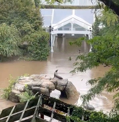
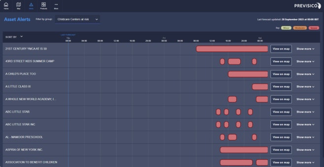
Examples of the visualization of the New York Flood on September 29 from Previsico’s Flood Dashboard are shown below. The Manhattan region suffered flooding including areas in Central Park and the Central Park Zoo as observed in Figure 2. Additionally, the dashboard can provide information regarding the counties and/or assets at risk. The alerts for the assets at risk can be viewed from the “Alerts” page in the dashboard as seen in Figure 3. The alerts are displayed for assets that may be at risk of flooding with “minor”, “moderate” and “severe” alerts.

Validation
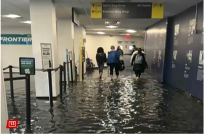
Observations were collected from over 90 data points including point data from real-time sensors and rain gauge data (FloodNet and CoRaHS Mapping System) news sources, and social media as depicted by the black triangles in Figure 1. These data points are also shown in the dashboard visualisation in the example below, the flood forecast was validated using flood information from real time sensors and other sources such as crowd sourcing. The observed flooding points match the Previsico’s flood forecast as shown in Figure 4 for Marcy Ave, Wallabout St and Harrison Ave. Similarly, Figure 5 shows the extensive flooding in JFK airport occurring on the 29th of September. Previsico has determined that our flood-forecasting model would have been able to predict the flooding event with 86% accuracy if our service was live in the location at the time.


References
Hicks, Nolan. ” Gov. Kathy Hochul declares emergency after torrential rains flood swaths of NYC.” New York Post, September 29, 2023. Accessed October 17th, 2023.
Zerkel, Eric, Mary Gilbert, and Aya Elamroussi. “Record rain in New York City generates ‘life-threatening’ flooding, overwhelming streets and subways.” CNN, September 30, 2023, 2:12 AM EDT. Accessed October 17th, 2023.
“FloodNet NYC.” Accessed October 17, 2023. https://www.floodnet.nyc/.
“COCORAHS Maps.” Accessed October 17, 2023.
El-Bawab, Nadine, and Meredith Deliso. “28 rescued in ‘historic’ New York storm, state of emergency to remain: Gov. Hochul.” ABC News, September 30, 2023. Accessed on October 17, 2023.